

New Orleans is a city with a lot of history, and each of the city’s neighborhoods has its own distinct role in the city’s history. This guide highlights five of New Orleans’ historical neighborhoods: the French Quarter, the Garden District, the Arts and Warehouse District, Mid-City, and Tremé. The walking tour outlined for each neighborhood is a great way for you to explore the city and learn more about its history at your own pace.
The French Quarter
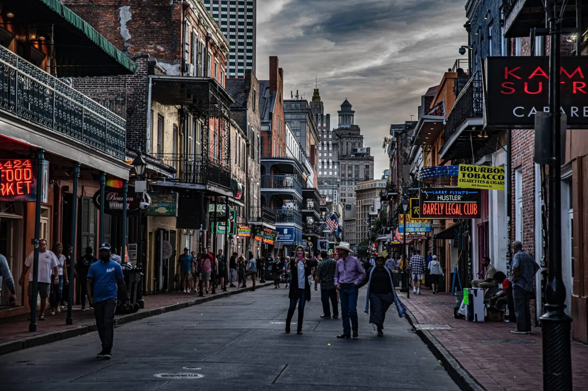
When people think of historical New Orleans areas, the French Quarter is probably one of the first places to come to mind. Also known as Vieux Carre (Old Square), the French Quarter is the oldest neighborhood in New Orleans. The French Quarter was originally a walled city founded by the French so that they could regulate commerce traveling on the Mississippi River. Today, the French Quarter is a popular neighborhood for tourists to visit that’s known for its nightlife, especially on Bourbon Street. If you want to learn more about this area’s history, your tour starts at the French Market.
French Market
The French Market is an open-air market known for its shopping, dining, and music. It is the oldest public market in the United States, and it spans six blocks from Cafe Du Monde to the flea market at the end of Esplanade Avenue. The French Market was founded in 1791 and it was originally a Native American trading post along the Mississippi river. Then, French and Spanish colonists began to expand the market by opening it up to merchants from all over the world, leading to the establishment of the French Market as an important cultural and commercial area of New Orleans. The market continued to expand over the next three centuries as immigrants from Europe, Africa, and the Caribbean opened their own stands in the market selling a diverse variety of products. In the late 19th century, Joseph Abeliard, who was one of the first Black architects in the United States, built a structure called the Bazaar market which included a butcher’s market, a fruit and vegetables market, and a fish market. In 1915, a hurricane destroyed this building, but it was restored in 1930 and continued to sell food and produce. This building still stands today, however, since the 1970s, the space has instead been occupied by retail vendors selling stuff such as souvenirs, clothing, and art. From the Shops of the Colonnade, you can walk through the French Market to the other end, where you will reach your next stop: Cafe Du Monde.

Café Du Monde
The Café Du Monde coffee stand was founded in 1862 as part of the French Market. The coffee place is very popular and often crowded, but it is open 24 hours a day 7 days a week. Café Du Monde’s menu has barely changed since it was founded, and part of the reason it still is so popular today is because of this simplicity. The coffee served at Café Du Monde stands out because it is cut with chicory, making the coffee rich and dark. Cutting coffee with chicory is a New Orleans tradition that started during the Civil War when coffee was in short supply. They are most famous for their beignets, a classic New Orleans dessert, which are square pieces of deep fried dough that are topped with powdered sugar. The tables at Café Du Monde also offer a cool view of Jackson Square, which is your next stop.

Jackson Square
Jackson Square is a historic park in the heart of the French Quarter in New Orleans. A few years after New Orleans was founded in 1718, a French landscape architect named Louis H. Pilié sought to organize the new city into a formal colony by creating a layout that was modeled after the oldest square in France, the Place des Vosges. At the center of his design was Jackson Square, which was a one-block area used for an open-air market and military parades. It became an important area for shipping and commerce in New Orleans, but it also became a place for locals to gather. The square also has a darker history, as it became known for its public executions throughout the 18th and 19th centuries. Jackson Square was originally controlled by the French colonists, then the Spanish, then the French again until 1803 when the United States gained control of the territory after the Louisiana Purchase.The square was originally called Place d’Armes, but it was later renamed after Andrew Jackson because of his achievements during the Battle of New Orleans in 1815, which was the United States’ greatest land victory against the British during the War of 1812. Andrew Jackson was also honored with an equestrian statue of him in the square. Jackson Square is surrounded by famous historical buildings, such as the St. Louis Cathedral, the Louisiana State museums, and the lower and upper Pontalba Apartments, which are the oldest apartment buildings in the United States, built in 1850. Today, Jackson Square is best known for the local artists there that paint, draw, and show off their work around the square, and it is often referred to as an “open-air artist colony”. Now, you can walk to the end of the square to St. Louis Cathedral, your next stop.

St. Louis Cathedral
St. Louis Cathedral was built in 1727, making it the oldest continuously active Roman Catholic Cathedral in the United States. The original cathedral burned down during the great fire of 1794, but it was rebuilt, and the cathedral that stands today was finished in the 1850s. Because the Spanish were in control of Louisiana immediately after the Great Fire of 1794, they oversaw the rebuilding of the cathedral, so St. Louis Cathedral is characterized by Spanish colonial style architecture. The impressive architecture of St. Louis Cathedral and its towering over Jackson Square makes this landmark one of New Orleans’ most recognizable. The image of the cathedral opening up to a plaza is a popular subject for photographers and filmmakers, and this image has been seen in hundreds of movies and t.v shows set in New Orleans. Because New Orleans was founded by French colonists, Catholicism has been an important part of the city’s culture since the beginning. The importance of Catholicism in the city’s history is clear through St. Louis Cathedral, as the cathedral was given a prominent status in the city. When plans for the city’s streets were drawn in 1720, the original small, wooden chapel, where St. Louis Cathedral now stands, was used as the center of the street grid. Then in 1727, the chapel became a proper parish church, and it was New Orleans’ first church. Before you head to your next stop, you should take time to walk around the inside of the cathedral where you can see the beautiful architecture and stained glass windows. For your next stop, you can head over to Pirate’s Alley, which is behind St. Louis Cathedral off of Chartres Street.
Pirate’s Alley
Pirate’s Alley was originally built as a passageway through the French Quarter. This New Orleans alleyway became famous because of its popular ghost stories and legends of pirates. However, historians say that there is no strong historical backing for legends of pirates in this alleyway. A lot of historians argue that it actually is very unlikely that pirates ever did business here, since the alley is right next to a church and is in one of New Orleans’ busiest neighborhoods. The alley was originally called Orleans’ Alley until the mid-1960s when its popular nickname “Pirate’s Alley” became the official street name. Since the 1980s, Pirate’s Alley has become accessible only to pedestrians, making it a popular spot for shops and bars. Walk to the end of Pirate’s Alley, and turn right on Royal Street, which is your last stop.

Royal Street
Royal Street is famous for its antique shops and art galleries, and you should take time to look in some of these unique stores. Royal street is one of the city’s original streets from the 18th century, and it is known as New Orleans’ first business street. When New Orleans was founded in 1727, a simple grid system was created to organize the city’s streets. Starting at the river, the streets went back several blocks starting with Rue Victorie, then Rue Chartres, then Rue Royale. Rue Cartres is in front of St. Louis Cathedral and the main government building for the colony at the time, so that is where wealthy and influential New Orleans residents built their homes. On the street behind Rue Cartes, Rue Royal, is where businesses were established that did not require direct access to the water, and the families running those businesses built their homes there. During the Great Fire of 1794, the Spanish colonists were in control of New Orleans so they oversaw the neighborhood’s reconstruction. Today, you can still see the Spanish colonial style architecture in the buildings that line Royal Street, with the brick homes built around a courtyard. At the time, nobody wanted to live on street level, so the empty street level spaces in these buildings were perfect for businesses to occupy. Royal Street definitely is known more for its daytime appeal compared to the parallel Bourbon Street, which is known for its nightlife with a lot of bars and clubs, and there is a historical reason for the distinct difference between these two streets. In the 1860s, street railways were being built to connect the French Quarter with other parts of the city. The streets were too narrow for a two-way rail system, so the street cars traveled away from the French Quarter on Royal Street and back into the French Quarter on Bourbon Street. This led to Royal Street becoming associated with going to work in the business district, while Bourbon Street became associated with coming home from work, making it an ideal place for bars to open up.

The Garden District
The Garden District is part of the Uptown District of New Orleans. The district was founded by Americans moving to New Orleans who wanted to distance themselves from the French who were living in the French Quarter. The district was previously made up of plantations which were sold in pieces to wealthy Americans who then built their mansions, some of which you can still see today. The neighborhood is famous for its mansions, you will find some of the biggest and most lavish mansions in New Orleans here. If you want to learn more about this neighborhood’s history, your tour starts at The Columns Hotel on St. Charles Avenue.
The Columns Hotel
The Columns Hotel has become famous because of the rumors that it is haunted. Guests of the hotel have reported seeing and talking to a well-dressed man in the lobby or at the door of their rooms. Others have talked about seeing the ghost of a little girl wandering around the hotel. The hotel was originally built in 1883 as a private residence for a tobacco merchant named Simon Hernsheim. In 1895, Hersheim’s wife and sister both died of unclear causes, which led to Hersheim committing suicide in 1898 and the house fell out of the hands of the Hersheim family. In 1917, the building was transformed into an upscale boarding house until it became a hotel in 1953. By this point the hotel had fallen into extreme disrepair, and it was frequently used by New Orleans politicians to meet up with female escorts. The hotel was purchased in 1960, and the owners restored the building and fixed its bad reputation. Today, the hotel’s bar, the Victorian Lounge, is a popular spot for both locals and tourists to hang out. When you are done checking out the Columns Hotel, you can continue walking down St. Charles’ Avenue towards Amelia Street.

St. Charles Avenue and the St. Charles Streetcar
St. Charles Avenue is famous for the dozens of mansions that line the street. You can walk down this street to see all of these historic homes or you can hop on the St. Charles Streetcar to see the buildings as you ride by. After the district was first founded, each block only had two mansions with large gardens which is where the neighborhood got its name. In the late 1800s, these large lots started to be divided in order to build more houses as the area became more urban. These new houses were late Victorian style homes, and the pattern of mansions surrounded by these Victorian houses is what makes the architecture unique in the Garden District. As you walk along St. Charles Avenue, you will also see some raised center-hall cottages, which are urban versions of French-Colonial plantations. The houses are raised above street-level and are characterized by porches that reach all the way across the front of the house with columns. For your next stop, you are going to continue down St. Charles Avenue until you get to Sixth Street. Then, turn right and walk over to Lafayette Cemetery No. 1.

Lafayette Cemetery no. 1
New Orleans is famous for its above ground cemeteries, which were built because the city has a large water table which means when graves were dug they often became full of water. Lafayette Cemetery no. 1 is one of the oldest city governed cemeteries. It was founded in 1833, and it’s still in use today. Lafayette Cemetery no. 1 is known as the city’s first planned cemetery. It’s also known for its well-planned layout as well as the architecture of the cemetery’s tombs and mausoleums. The cemetery was named after the city of Lafayette, which was a suburb that was annexed by New Orleans in 1852. The cemetery is famous for having the graves of some of the first New Orleans settlers from Ireland and Germany, and it has over 7,000 people buried here. From Lafayette Cemetery no. 1, turn right on Washington Avenue and then left on Coliseum Street. Walk on Coliseum Street until you get to Third Street, where you turn left. Then, your next stop will be on the right at 1415 Third Street: The Walter Grinnan Robinson House.

Walter Grinnan Robinson House
The Walter Grinnan Robinson House is one of the Garden District’s famous mansions. The Italianate-style mansion was built in 1859 by Henry Howard, a famous New Orleans architect. The mansion is one of the neighborhood’s largest, and it’s famous for its unusual, curved portico, which is a porch leading to the entrance of the building with a roof over it. The curved roof collected water and acted as a place used to store water. With the help of gravity providing water pressure, this mansion was able to have the first indoor plumbing in the Garden District. To get to your next stop, continue on Third Street towards Prytania Street and then turn right. Your last stop, Women’s Guild of New Orleans Opera house, will be on the right at 2504 Prytania Street.

Women’s Guild of New Orleans Opera House
Another famous home in the Garden District belongs to the Women’s Guild of New Orleans Opera. When the owner of the house, Nettie Kinney Seebold, died in 1965, she left the house to the Women’s Guild of New Orleans Opera in her will. She had studied music when she was younger and loved the arts, particularly opera. In her will, she requested that the home not be renovated and the treasures inside dating back to the 18th and 19th century not be sold. The Seebolds traveled frequently and brought back treasures for the house which are still there today, such as chandeliers from the Winter Palace in Russia and the Hamilton Palace in Scotland.

Arts and Warehouse District
This New Orleans neighborhood, originally named the Industrial District, was founded in the 19th century to store products that were passing through New Orleans Port on their way to other parts of the country. Despite the World’s Fair of 1984 which New Orleans hosted going bankrupt, the first world-fair to ever do so, it still stimulated long term economic growth, particularly in the Arts and Warehouse District. After the fair, the district was transformed, becoming an important cultural and artistic area of the city. The architecture in this New Orleans neighborhood is unique. Because the district was founded to store goods, the area was full of old, industrial warehouses. These warehouses are still here today, but they have been converted into museums, art galleries, restaurants, and apartment buildings. If you want to learn more about this area, your first stop is at Fulton Street Square.
Fulton Street Square
Prior to the 1980s, Fulton Street Square had very little going on and was mostly just old warehouses. This changed during the 1984 World’s Fair when a section of Fulton Street Square was included within the fair’s boundary. The square was home to a number of popular exhibitions that were part of the fair, such as the Italian village. Fulton Street Square was a prominent area in the Arts and Warehouse District that experienced revitalization following the fair. Today, the one-block section of Fulton Street that makes up the square is a pedestrian-only area outdoor mall full of shops and restaurants. The square is a strong symbol of how the neighborhood was transformed and began to have economic prosperity following the 1984 World’s Fair. To get to your next stop, Julia Street, head up Lafayette Street towards St. Peters Street, then turn left on Magazine Street. Keep walking straight on Magazine Street until you hit Julia Street.

Julia Street
In the heart of New Orleans’ Art and Warehouse District, Julia Street is nicknamed “Gallery Row” because of all of the art galleries that line the street. As part of an industrial area, this street was originally established to store grain, coffee, and produce imported from the Port of New Orleans. However, after the 19th century when shipping practices became more advanced, Julia Street became less prosperous until the 1984 World’s Fair when the whole Warehouse District was revitalized. After the 1984 World’s Fair, the empty factory buildings were transformed into luxury apartments and the street-level vacant spots became art galleries. Today, these art galleries feature a variety of art from both famous local and national artists. You can find even more art galleries on the nearby Camp Street. Your next stop is the Contemporary Arts Center. To get there, walk up Julia Street towards Camp Street, then turn left. The Contemporary Arts Center will be on the left on Camp Street.

Contemporary Arts Center
The Contemporary Arts Center is in a historic 1905 warehouse that was renovated in 1990. The arts center was founded in 1976, and many consider it to be a leading force in the transformation of the Arts and Warehouse District into the cultural heart of New Orleans that it is today. The Contemporary Arts Center is full of modern visual exhibitions including experiments in painting, music, theatre, dance, photography, sculpture, video, and more. Your last stop is at another popular art museum in the Arts and Warehouse District, the Ogden Museum of Southern Art. To get there, keep walking straight on Camp Street, in the same direction that you came, and it will be on your right.

Ogden Museum of Southern Art
The Ogden Museum of Southern Art opened in 2003 and showcases the largest collection of art from Southern artists in the world. The museum has 4,000 pieces of art donated by art collectors from 15 Southern states and Washington D.C. The Ogden Museum of Southern Art was named an affiliate of the Smithsonian museum, making it the first museum in New Orleans to achieve this status. The museum’s collection includes a variety of art including paintings, watercolors, photographs, prints, and sculptures. The collection focuses on the South’s history from 1733 to the present.

Mid-City
Mid-City is a quieter area of the city compared to the downtown and French Quarter neighborhoods of New Orleans. The neighborhood is known for its above ground cemeteries, parks, and beautiful architecture. You can take the Canal Streetcar line to get there, which starts at the French Quarter, goes through the Central Business District, and then goes onto the center of the Mid-City district at the corner of Canal Street and Carrollton Avenue.
Canal Street and North Carrollton Avenue
Canal Street and North Carrollton Avenue is the heart of Mid-City. Before you head over to your next stop, you should take some time to walk around Canal Street, a lively area in Mid-City known for its shopping with lots of small stores and boutiques and newly-restored theatres. When people began to settle in the American sector of New Orleans, which today includes the Uptown District and the Central Business District, away from the French in the French Quarter, Canal Street was considered neutral ground between the American and the French New Orleans residents. Canal Street is also famous for its parades. It’s a popular spot to watch the parades during Mardis Gras, and it also hosts a big Christmas parade. The street has been hosting parades since the mid-1800s. Your next stop is St. Patrick’s Cemetery no. 3, which is around a 20 minute walk from the corner of Canal Street and North Carrollton Avenue, but if you don’t want to walk, you can get on the Canal Streetcar-Cemeteries line to get there. If you want to walk, walk up Canal Street towards David Street, and the cemetery will be on the right.
St. Patrick’s Cemetery no. 2
St. Patrick’s Cemetery no. 2 was built in 1853. A large number of Irish immigrants began to come to New Orleans in the 1820s and 1830s. In 1833, there were enough Irish people in New Orleans to organize their own church, St. Patrick’s, which became the second-oldest Catholic church in the city. St. Patrick’s Cemetery no. 2 was the first cemetery in New Orleans that was built for the Irish community in New Orleans after the Yellow Fever epidemic. The Irish community in New Orleans was hit the hardest by the Yellow Fever epidemic, because many of them worked outdoor day labor jobs, which increased the risk of being exposed to the disease. St. Patrick’s Cemetery no. 2 is different from St. Patrick’s Cemetery no. 1 because of the quality of graves. When St. Patrick’s Cemetery no. 1 was being built, most Irish New Orleans residents were not wealthy, so they were built in “copings” which were poorly dug in-ground graves. As St. Patrick’s Cemetery no. 2 was being built, the city was recovering from the epidemic and the Irish community were climbing up the New Orleans social ladder. Their social mobility during this time is reflected in St. Patrick’s Cemetery no. 2, which mainly has higher quality, above-ground graves. Your next stop is another famous cemetery in Mid-City: the Masonic Temple Cemetery. To get there, head up Canal Street and then turn right on City Park Avenue. The cemetery will be on your right.

Masonic Temple Cemetery
The Masonic Temple Cemetery was founded in 1865 by the Grand Lodge of the State of Louisiana Free and Accepted Masons. This New Orleans cemetery is unusual compared to other Catholic cemeteries in the city, because of the communal nature of the cemetery. Members of freemasonry groups would all pitch in to buy large group tombs. These large group tombs are very elaborate and look unusual compared to the smaller, individual tombs in other New Orleans cemeteries. The layout of the cemetery is also unusual, as it covers two city blocks in a triangular shape. Conti Street cuts through the cemetery, splitting it up into two distinct sections. Next up is City Park. To get there, continue walking up City Park Avenue towards Toulouse Street.

New Orleans City Park
The New Orleans City Park is one of the largest urban parks in the country. It’s one mile wide and three miles long with lots to see and do from nature preservation areas to art displays. The land was previously the Allard plantation, and when the land’s owner, John McDonogh, died, he left the land to his home city Baltimore and New Orleans. In 1854, the 4th District Court pronounced the land a public park after they gained clearer ownership of the land. However, the land remained mostly unused until 1872 when the city contacted landscape architects to make designs for the park. The park’s board felt that the plans drawn weren’t good enough, and they refused to pay the architects’ the second half of their fee. In 1873, the landscape architects sued for the rest of the money the board owed them, and won it after appealing to the Louisiana Supreme Court. In 1891, the City Park Improvement Association was founded and the park finally began to become more developed. Some cool places to check out in the Southern section of the park, near Mid-City, are the New Orleans Botanical Garden and the New Orleans Museum of Art.

Tremé
Tremé is another cool neighborhood with a lot of history to check out while you are in New Orleans. In the 1700s, the area that is now Tremé was a plantation. In 1810, a real estate developer and hat maker named Claud Tremé subdivided the land and sold it to the city of New Orleans, which then became home to free Black people and other people of European descent. Tremé is full of Creole architecture through the cottages from the 1830s, the townhouses from the 1840s, and the double shotguns built in the 1890s, which are two houses that share a central wall, allowing more houses to be fit into an area. If you are interested in learning more about this neighborhood, your first stop is Congo Square.
Congo Square
In the late 18th century when Spanish colonists controlled New Orleans, they gave slaves Sunday afternoons off because they recognized it as a day of rest. During their time off, slaves were allowed to gather and socialize but only outside of the city limits in an open area north of Rampart Street which became known as Place Congo. At this popular gathering spot, slaves would play music, sing, and dance. When Americans gained control of the city, New Orleans began to expand beyond the French Quarter and Place Congo became known as Congo Square. Gatherings in Congo Square continued into the 1880s even after the Civil War. During this time however, white city leaders tried to put an end to these large gatherings. One way they did this was by renaming the square to “Beauregard Square,” after a Civil War General. Despite the square being renamed, New Orleans locals continued to refer to it as Congo Square, and it was officially named Congo Square in 2011. Your next stop is Armstrong Park, which Congo Square is part of. You can walk up North Rampart St toward Orleans St to get to the other section of the park. The main entrance for pedestrians is at North Rampart and St. Anne Streets.

Louis Armstrong Park
Louis Armstrong Park is a 30 acre park designed to honor New Orleans’ musical history and preserve Congo Square which played an important role in the city’s musical history. The park is named after one of the most famous jazz musicians to come out of New Orleans: Louis Armstrong. You can see sculptures and other sites in the park paying tribute to the city’s jazz tradition. The park was built by the city in the 1960s and 1970s as part of an urban renewal project which led to the controversial destruction of a section of housing in the Tremé neighborhood. In 1970, the park hosted the first New Orleans Jazz and Heritage Festival, which is also known as Jazz Fest. To get to your next stop, walk up North Rampart Street towards St. Philip Street, then turn left on Ursulines Avenue. Turn right onto Henriette Delille Street, and your stop will be on the right: the Backstreet Cultural Museum.

Backstreet Cultural Museum
Mardis Gras is an iconic tradition that New Orleans is famous for. However, a lot of people may not know about the important role that the Mardis Gras Indians play in putting the celebration together. This group has roots in the late 18th and 19th centuries when Louisiana indigenous tribes would help runaway slaves from New Orleans. Mardis Gras Indian culture has influences from these indigenous groups as well as the bond created between slaves and Native Americans. Today, there are more than 40 Mardis Gras Indian tribes found in Louisiana with each tribe having their own traditions, history, and style. There are different hierarchical positions in each tribe, with each position having an individual responsibility. Mardis Gras Indian suits are hand-sewn and take an entire year to create. The suits are only worn once, and they feature hundreds of thousands of beads, sometimes weighing as much as 150 pounds. The Backstreet Cultural Museum has the city’s largest collection of Mardis Gras Indian suits as well as other memorabilia from Mardis Gras. Your next stop is the St. Augustine Catholic Church. To get there, walk up Henriette Delille Street toward Governor Nicholls Street, then turn left on Governor Nicholls Street and the church will be on the left.

St. Augustine Catholic Church
St. Augustine Church is the oldest African American Catholic parish in the nation which was founded in 1841. In the 1830s, a group of free African American New Orleans residents began efforts to create a Catholic church in Tremé. Antoine Blac, the first Archbishop of New Orleans, blessed the parish, and the first ceremony was held there in 1842. After the church was founded, white Catholics were angry that a church was being built for black New Orleans residents. They began to buy pews in an attempt to outnumber the black members of the church, but their effort was a failure and free black New Orleans residents significantly outnumbered them. Also, black members of the church pooled their resources to buy pews for slaves, which historians believe is the first instance of this in American history. The church was designed by J.N.B de Pouilly who also worked on the renovations of the St. Louis Cathedral in the French Quarter. On the side of the church you can see the Tomb of the Unknown Slave, which is a fallen cross that was built as a memorial for the slaves who died in New Orleans and were buried in unmarked graves. Your next stop is Tremé’s Petit Jazz Museum. To get there, continue walking up Governor Nicholls Street toward Treme Street, and the museum will be on the left.
Tremé’s Petit Jazz Museum
Tremé’s Petit Jazz Museum was founded by Al Jackson, a Tremé native, who wanted to educate people about the neighborhood’s music history free from what he calls “the typical Eurocentric standpoint” from which musical history is normally told. Although the museum is only one room, it provides a thorough audiovisual account of the history of jazz in New Orleans as well as the other styles of international music that influenced the development of jazz, including African, Afro-Caribbean and European influences. The museum also has other important historical records relating to New Orleans’ jazz history, such as recording contracts and correspondences between famous jazz musicians.
